Milestone-Proposal:LORAN: Difference between revisions
From IEEE Milestones Wiki
(Article updated via HTTP request) |
(Article updated via HTTP request) |
||
| Line 47: | Line 47: | ||
Willoughy, Malcolm Francis; The Story of LORAN in the U.S. Coast Guard in World War II, Arno Pro, 1980. | Willoughy, Malcolm Francis; The Story of LORAN in the U.S. Coast Guard in World War II, Arno Pro, 1980. | ||
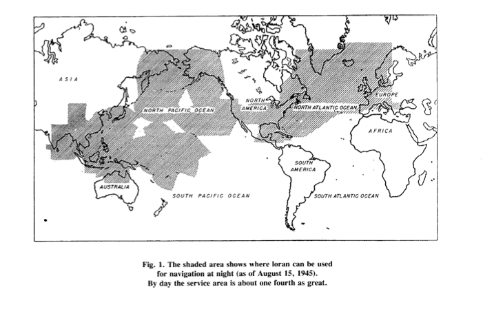
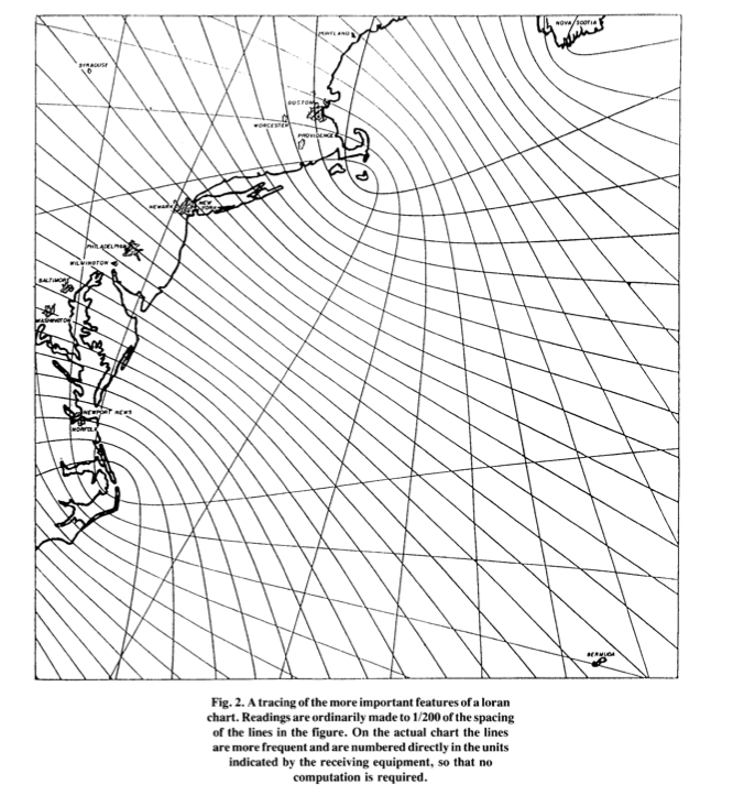
Also see other historical references identified by JA Pierce in 1946 on page 33 of "An Introduction to Loran".|a5= | Also see other historical references identified by JA Pierce in 1946 on page 33 of "An Introduction to Loran".|a5= Loran is a hyperbolic system of navigation by which difference in distance from two points on shore is determined by measurement of the time interval between receptions of pulse- modulated synchronized signals from transmitters at the two points. Both ground waves and sky waves can be used to provide coverage over an extensive area with few stations, depending on design frequencies. An important advantage of loran at the time of its development during World War 2 was that a ship could use loran without breaking radio silence. Loran transmitting stations work in pairs. Synchronization is achieved by letting the signals of the master station, control those of the slave station. To help overcome the disadvantage of requiring two transmitting stations for a single family of hyperbolic lines of positions, loran forms a chain of stations, so that each station except the end ones operate with the station on either side to form an intersecting lattice of position lines. To find his way, a loran navigator on a ship had to be trained, have a loran receiver-indicator, and a set of loran nautical charts or loran tables. Standard loran was initially developed primarily for navigation over water. It was also used for air-borne navigation. | ||
Today's loran operates on one of several frequencies between1700 and 2000 kHz. It enjoys propagation characteristics determined primarily by soil conductivity and ionosphere conditions. Both ground wave and sky waves can be used to provide coverage over an extensive area with few stations. Usually, stations of a pair are located 200 to 400 miles or more. At one time, 1000 to 1400 miles apart separated several station pairs. Transmitters now in use radiate about 100kw and give a ground-wave range over seawater of about 700 nautical miles in the daytime. The daytime range over land is seldom more than 250 miles even for high-flying aircraft and is scarcely 100miles at the surface of the earth. At night the ground-wave range oversea water is reduced to about 500 miles by the increase in atmospheric noise, but sky waves, which are almost completely absorbed by day, become effective and increase the reliable night range to about 1400miles. Generally, a number of stations are located so as to form a chain, with all but the end station in the group being double pulsing. In most parts of the world, signals can be received from at least two pairs of stations making it possible for a mariner to determine a fix using loran alone. | |||
Today's loran operates on one of several frequencies between1700 and 2000 kHz. It enjoys propagation characteristics determined primarily by soil conductivity and | A full and complete description of the evolution of loran is provided in the attached article by JA Pierce entitled | ||
"An Introduction to Loran", Proceeding of the IRE, 1946. Reprinted by IEEE AES Magazine 1990. | |||
INSERT PIERCE ARTICLE HERE. | |||
The Gee System in Britain | |||
At the time that loran was being designed, there existed in Britain a similar navigation system being developed called Gee. Gee was also a pulse-modulated hyperbolic navigation system, similar to loran. Gee operated at ultra-high frequencies and was limited to line-of-sight distances, of 400 miles or so. Gee was intended for aircrafts traveling short distances; not long sea voyages. In mid-1942, R. J. Dippy, who had invented the Gee system, came to the United States for eight months to assist in loran development. Pierce admits that Dippy's basic concept was borrowed by American scientists working on long-range navigation but not Gee designs and nor techniques. He acknowledges that "Loran copied gee's concepts rather than techniques and may be said to have been invented in America in the sense in which Galileo is said to have invented the telescope". | |||
We can conclude here that Gee was not an acceptable alternative to loran. | |||
|a6=|a7=It should be noted at this time, that the radio navigation Loran project was not carried out at the iconic "Radiation Laboratory" building home of radar / microwave innovations. Instead, the project engineering team worked in the Hood Building in Cambridge, close to but off the MIT campus. Further research will be carried out to locate this building. Rad Lab was awarded an IEEE Milestone .......... | |a6=|a7=It should be noted at this time, that the radio navigation Loran project was not carried out at the iconic "Radiation Laboratory" building home of radar / microwave innovations. Instead, the project engineering team worked in the Hood Building in Cambridge, close to but off the MIT campus. Further research will be carried out to locate this building. Rad Lab was awarded an IEEE Milestone .......... | ||
The proposed milestone plaque could be mounted on MIT Building N42, on Massachusetts Avenue, close to where the original Hood Building used to be. The Boston Section Milestone Committee is currently seeking approval from MIT to carry this out | The proposed milestone plaque could be mounted on MIT Building N42, on Massachusetts Avenue, close to where the original Hood Building used to be. The Boston Section Milestone Committee is currently seeking approval from MIT to carry this out | ||